Winner in 8 Wonders of Kansas Geography
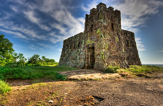
Coronado Heights is the southern-most bluff in a series of seven, known as the Smoky Hills. The hill is located northwest of Lindsborg. It is believed that Francisco Vasquez de Coronado and his men viewed the prairie from this lookout point 300 feet above the valley floor. Chain mail from Spanish armor was found in the area by Bethany college professor J.A. Udden in 1915. Others have found Spanish coins, a bridle, and lead bars in the valley.
Sumac, yucca, spiderwort, butterfly milkweed, sand hill plum and gooseberries are just some of the plants you will find. If you are lucky, you might see a lizard or two. Native Dakota sandstone was used to build the castle and picnic areas in 1936 as a project of the Works Progress Administration, creating the perfect opportunity for a picnic, flying kites, hiking or riding the off-road bike trails. Do not forget your camera! It is a favorite of photographers and artists alike.
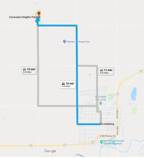
At the intersection of Main and Lincoln downtown Lindsborg head west on Lincoln. Turn north or right onto Coronado Ave / 13th Ave and go 2 miles. Turn west or left onto Coronado Heights Rd and drive 1 mile to the opening to Coronado Heights. Follow the road to the top.
For more information visit the Smoky Valley Historical Association Website
Full History of Coronado Heights and Höglund Dugout
Are you a geocacher? Locate and document the Earth Cache located at Coronado Heights at geocaching.com. An Earthcache is a special place that people can visit to learn about a unique geoscience feature or aspect of our Earth, leaving no damage to the location.